Chasing the Record
The standing Great Lakes Assault record is 8 hours, 10 minutes, 47 seconds — set on August 12, 1995 by Mark Nemschoff and Fabio Buzzi aboard Kohler Power Systems, a 40-foot FB Design catamaran running twin 750hp Seatek turbodiesels. Chuck Norris's 1990 run (12:08:42 in a 46-foot Wellcraft Scarab) is the famous one. Nemschoff and Buzzi's is nearly 4 hours faster, and it's what a modern attempt actually has to beat.
The Kohler Power Systems record of 8:10:47 represents a 74 mph average in a 1,500hp diesel catamaran from 1995. A modern 2,000hp outboard catamaran targeting 80–85 mph cruise should better that time by 30–90 minutes depending on conditions and fuel strategy.
The Technology Gap
The Kohler Power Systems record was set with 1,500hp and averaged 74 mph. Modern quad-outboard catamarans run 2,000–2,400hp and cruise at 80–95 mph. That's a 33–60% power increase translating to 8–28% higher cruise speeds — enough to cut 30–90 minutes off the standing record under equivalent conditions.
| Specification | 1995 Kohler Power Systems ← Record | Modern Capability | Advantage |
|---|---|---|---|
| Hull | 40ft FB Design catamaran | 44ft stepped cat (MTI 440X class) | Better wave handling, fuel capacity |
| Horsepower | 1,500 hp (twin 750hp Seatek turbo) | 2,000–2,400 hp (quad outboard) | +33–60% power |
| Average Speed | ~74 mph | 80–95 mph sustainable | +8–28% faster cruise |
| Projected Time | 8h 10m 47s | 6h 45m – 7h 30m | 40–90 min improvement |
| Navigation | Early chartplotters | Integrated MFD, real-time GLERL wave data | Route optimization in real time |
| Fuel Efficiency | ~40–50 GPH (diesel turbo) | ~120–140 GPH (quad gas outboard) | Kohler advantage — likely ran non-stop |
Speed vs. Record Time
| Average Speed | Est. HP Required | Time (605 mi) | vs. Kohler 1995 Record |
|---|---|---|---|
| 74 mph | ~1,500 hp | 8h 10m | = Standing Record |
| 80 mph | ~1,800 hp | 7h 34m | 36m under |
| 85 mph | ~2,000 hp | 7h 07m | 1h 03m under |
| 90 mph | ~2,200 hp | 6h 43m | 1h 27m under |
| 100 mph | ~2,400 hp | 6h 03m | 2h 07m under |
Route Strategy
Route selection is a wave management problem, not a distance problem. The direct route and the shore-hug route differ by 15–20 miles — about 12 minutes at cruise speed. Under typical summer conditions, that distance gap is erased by calmer water on the longer route.
The bottom line: On a typical SW 15-knot summer day, the shore route runs in 1–2 ft waves — an 8% speed penalty adding ~19 minutes to the Lake Michigan leg. The direct route runs in 2–4 ft — a 18–30% penalty, adding 46 minutes to 1h 30m on the same leg. The 12–14 minute distance penalty of the shore route is recovered within the first 90 minutes. The direct route is only faster when the full lake is below 1 ft — conditions that occur roughly 10–15 days per summer and are predictable 48–72 hours in advance via GLERL WAVEWATCH III forecasts.
Why the Shore Route Works
Wave height depends on how far wind blows across open water. The prevailing summer wind on Lake Michigan is from the southwest. That single fact determines everything: the SW wind blows across 80 miles of open water before hitting the Michigan shore (downwind), but the Wisconsin shore (upwind) sits in the wind shadow with minimal wave buildup.
Lake Michigan northbound (Chicago → Straits): The western Wisconsin shore is sheltered from SW winds — the wind arrives from land with no fetch. The direct route and the eastern Michigan shore catch the full wave buildup after 80 miles of open water. In a 15-knot SW wind, the difference can be 2–3 feet of wave height.
Lake Huron southbound (Straits → Port Huron): Same logic applies — the western Michigan shore of Lake Huron is sheltered under SW winds. The shore route stays protected for both lake legs.
One more factor: Great Lakes waves are steeper than ocean waves at the same height. Wave periods here average 3–4 seconds versus 8–12 seconds in the ocean. A 3-foot Lake Michigan chop hits a hull harder than a 3-foot ocean swell. Speed penalties on the lakes are worse than ocean-based estimates suggest.
Route Options Compared
| Factor | Shore Route (~620 mi) Western WI shore (north) · Western MI shore (south) |
Direct Route (~605 mi) Straight line across both lakes |
|---|---|---|
| Distance penalty | +15–20 mi (~12–14 min at 80 mph) | None |
| Wave height — SW 10 kt (light) | 0.5–1 ft | 1–2 ft |
| Wave height — SW 15 kt (typical) | 1–2 ft | 2–4 ft |
| Wave height — SW 20–25 kt (windy) | 2–4 ft | 4–7 ft |
| When direct route wins | — | Flat water everywhere (<1 ft) — about 10–15 days per summer |
| When shore route wins | Any day with SW wind above 10 kt | — |
Wave Height vs. Speed Penalty
The following table shows estimated speed penalties for a stepped performance catamaran running an 80 mph baseline in Great Lakes short-period chop. These are conservative estimates — actual penalty will vary with wave direction relative to course heading, hull length, and throttle management decisions.
| Significant Wave Height | Speed Penalty | Effective Speed | Lake Michigan leg time (280 mi open water portion) |
Time delta vs. flat water |
|---|---|---|---|---|
| Flat (<0.5 ft) | 0% | 80 mph | 3h 30m | — |
| 0.5–1 ft | ~3% | ~77.5 mph | 3h 37m | +7 min |
| 1–2 ft | ~8% | ~73.5 mph | 3h 49m | +19 min |
| 2–3 ft | ~18% | ~65.5 mph | 4h 16m | +46 min |
| 3–4 ft | ~30% | ~56 mph | 5h 00m | +1h 30m |
| 4–6 ft | ~45% | ~44 mph | 6h 22m | +2h 52m |
| >6 ft | 65%+ | <28 mph | Not viable for record attempt | |
Route Segments
The dominant leg — over half the total distance. Under typical summer SW conditions, the Wisconsin shore route is faster despite added miles. The wind blows from the SW, meaning the Wisconsin (western) shore is upwind and sheltered. Course heading is NNE, which puts a SW swell on the beam on the open water — beam seas at 80+ mph produce rolling motion that compounds speed penalty. The Wisconsin shore keeps the boat in the wind shadow until crossing toward Mackinac as the lake narrows.
Fixed regardless of route. Commercial vessel traffic, currents up to 3 knots, common fog. Transited at safe speed. Vessel Traffic Services should be contacted in advance. No time is recoverable here against safety and regulatory cost.
Southbound on Lake Huron. The western Michigan shore is the protected side under SW winds — same logic as Lake Michigan, shorter lake width (~50 miles at maximum vs. ~80 miles for Lake Michigan) means less absolute fetch even on the open lake. Typically the calmer of the two lake legs. Fuel stop options: Alpena (~170 mi from the Straits) and Lexington (~210 mi from the Straits) are the two practical stops on the Michigan shore for a two-stop fuel strategy.
Speed-restricted from start to finish. St. Clair River is a navigable channel with no-wake enforcement. Lake St. Clair averages 11 feet depth — channel navigation required, no wave concern but no speed opportunity either. Detroit River carries international boundary traffic and posted speed limits. This segment runs approximately 45–55 minutes regardless of conditions and cannot be optimised.
Navigation Considerations
| Area | Challenge | Strategy |
|---|---|---|
| Lake Michigan — shore route (WI side) | Harbor exclusion zones, shoals near river mouths | Maintain 2–5 miles offshore on Wisconsin side; pre-chart harbor zones |
| Lake Michigan — direct route | Full wave exposure from SW winds; beam seas at 80+ mph | Only viable when GLERL WAVEWATCH III confirms <1 ft across the full lake 48–72 hr ahead |
| Manitou Passage | Natural funnel; vessel convergence | Treat as a traffic area; do not press speed through here |
| Straits of Mackinac | Commercial traffic, currents to 3 kt, fog | Coordinate with Vessel Traffic Services; transit at safe speed |
| Lake Huron shipping lanes | Main freighter channel runs central to eastern lake | Western shore route stays clear; AIS monitoring throughout |
| Lake St. Clair | Average 11 ft depth; marked channel mandatory | No deviation from charted channel |
| Detroit River | International boundary, high traffic, speed limits | Stay in US waters; comply with posted restrictions |
Michigan law prohibits speeds exceeding 55 mph within 1 mile of shore on the Great Lakes and Lake St. Clair. All harbor approaches, river channels, and designated no-wake zones apply regardless of record attempt status. The St. Clair River and Detroit River segments are speed-restricted for their full length. The timing clock runs through all restricted segments — they cannot be excluded from elapsed time.
Weather Window Optimization
Chuck Norris's 1990 run was completed in persistent rain, buffeting winds, and 6–9 foot waves. The 1995 Kohler Power Systems record was almost certainly set in ideal conditions — NOAA buoy data for September 1995 shows a rare 48-hour glass-calm window on Labor Day weekend (September 4–5) with wave heights of 0.0–0.3m and light easterly winds. That window was followed 48 hours later by a cold front that produced 3.5-meter (11.5-foot) waves. The speed differential tells the story: Norris averaged 50 mph fighting 6-foot seas; Nemschoff and Buzzi averaged 76 mph on flat water.
The Great Lakes Difference
Great Lakes waves are fundamentally different from ocean waves. They're shorter-period (3-5 seconds vs. 8-12 seconds in the ocean) and steeper. This means:
- Waves feel rougher at equivalent heights
- Boats get more airborne, land harder
- Conditions can deteriorate incredibly fast
- Calm mornings can turn ugly by afternoon
Ideal Conditions Strategy
A stable high-pressure system parked over the Great Lakes region for 24-48 hours. Light winds under 10 knots, wave heights under 2 feet across both lakes. These conditions occur perhaps 10-15 times per summer - but with good meteorological support, they're predictable 48-72 hours in advance.
The Data: Any Waves = Abort or Accept Major Penalties
Wave exposure modeling using NOAA buoy severity data (Hs × steepness) reveals a stark reality: the Great Lakes Assault is a fair-weather-only proposition. Even moderate wave action produces time penalties that dwarf any route optimization gains.
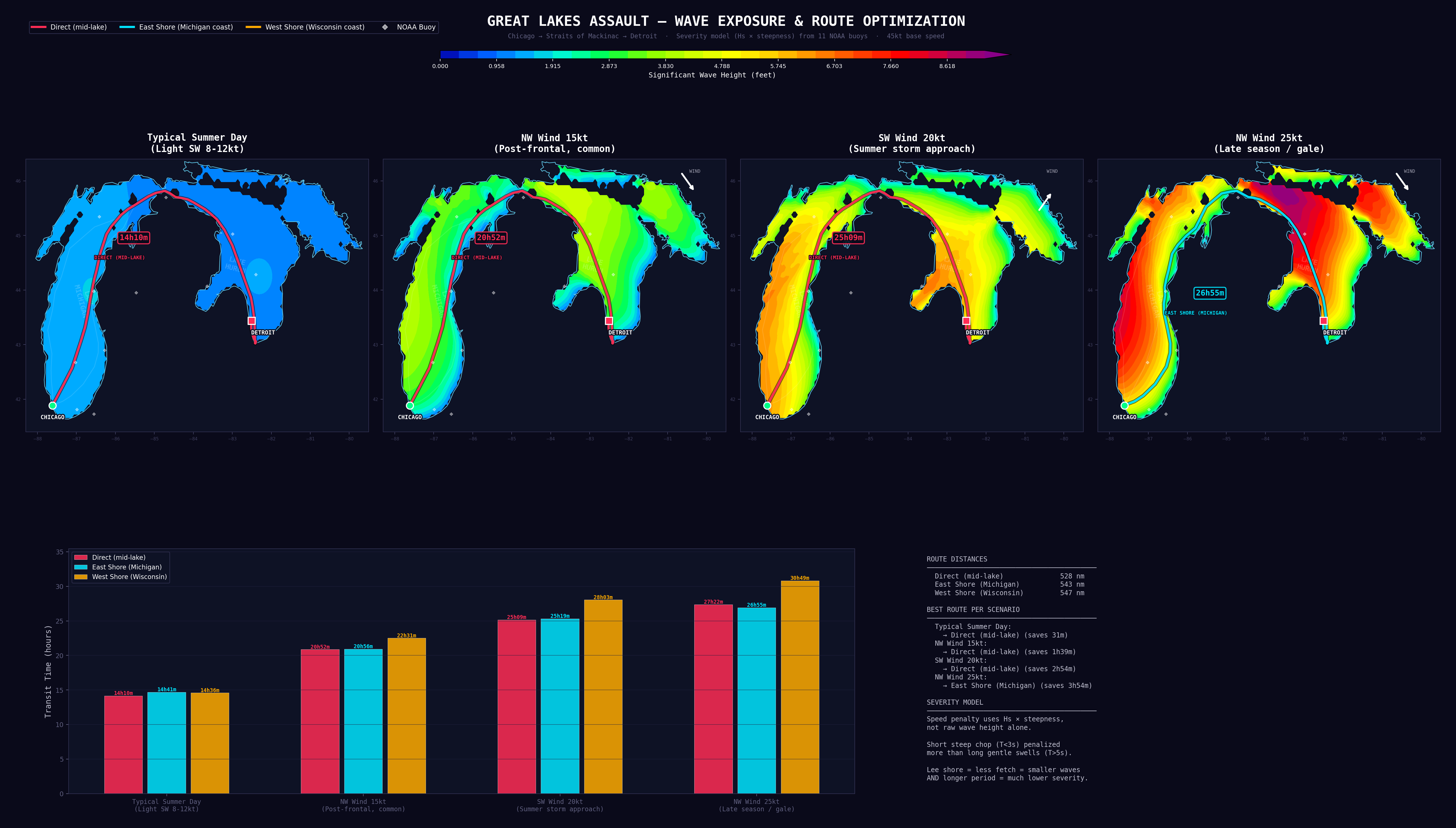
Wave exposure model showing transit times across four wind scenarios. Source: NOAA NDBC buoy data, 11-station severity model.
| Conditions | Direct Route | E. Shore (MI) | W. Shore (WI) | Verdict |
|---|---|---|---|---|
| Typical Summer Day Light SW 8–12kt |
~14h 10m | ~14h 34m | ~14h 43m | Go — any route |
| NW Wind 15kt Post-frontal, common |
~20h 52m | ~20h 06m | ~21h 32m | Marginal — E. Shore only |
| SW Wind 20kt Summer storm approach |
~26h 09m | ~25h 13m | ~27h 42m | Abort |
| NW Wind 25kt Late season / gale |
~30h 33m | ~26h 55m | ~31h 55m | Abort |
The conclusion is obvious but the data makes it undeniable: Wait for flat water. A "typical summer day" with light SW winds produces a 14-hour run — nearly 6 hours off record pace. Any wind above 15 knots pushes transit times to 20+ hours. The 1995 record required glass-calm conditions (the Labor Day window), and a modern attempt requires the same. Route optimization matters only at the margins; weather selection is everything.
The severity model uses Hs × steepness rather than raw wave height. Short steep chop (T<3s) is penalized more heavily than long gentle swells (T>5s). The eastern Michigan shore benefits from shorter fetch under N/NW winds — the dominant summer pattern — producing both smaller waves and longer periods. In rough conditions, the E. Shore route saves 3–5 hours despite being 15 miles longer.
Fuel Strategy
The 605-mile route requires careful fuel planning. At record pace, a modern quad-outboard setup will consume 100–150 gallons per hour. That's 600–900 gallons minimum. The question: carry it all, or stop to refuel?
The Kohler advantage: The 1995 record was set in a diesel turbo catamaran consuming roughly 40–50 GPH — about one-third the fuel burn of modern quad gas outboards. At that rate, a 400-gallon capacity covers 605 miles with margin. The Kohler Power Systems run likely completed with minimal or zero fuel stops.
Modern reference: For their NYC–Miami record attempt (1,768 miles), the Howes added 56 gallons to their MTI 440X's standard 150-gallon capacity — and still required multiple fuel stops. The efficiency tradeoff for modern outboard power is unavoidable.
The Math
| Configuration | Consumption at 80 mph | Fuel Needed (605 mi) | Typical Capacity |
|---|---|---|---|
| Quad Mercury 450R | ~100 GPH | ~750 gallons | 400-500 gal |
| Quad Mercury 500R | ~120 GPH | ~900 gallons | 400-500 gal |
| Quad Mercury V12 600 | ~140 GPH | ~1,050 gallons | 400-500 gal |
The verdict: You need to stop at least once, probably twice. The question is how to minimize stop time.
Fuel Stop Options
Maximum fuel capacity (800+ gal extended range). Single stop near the Straits of Mackinac (~330 miles). Requires custom fuel system modifications but minimizes total stop time.
Standard fuel capacity (~500 gal). Stop near Traverse City/Charlevoix (~220 miles) and again near Alpena/Mackinac (~180 miles). More conservative, more margin for error.
Pre-position a support vessel at a strategic location for rapid refueling. High-flow pumps can transfer 200+ gallons in under 5 minutes. Most time-efficient but requires significant coordination.
Key Fuel Locations
| Location | Distance from Chicago | Notes |
|---|---|---|
| Traverse City / Grand Traverse Bay | ~200 miles | Multiple marinas, easy access |
| Charlevoix | ~250 miles | Major marina, high-flow pumps available |
| Mackinaw City | ~330 miles | Just before Straits crossing |
| Alpena | ~400 miles | Lake Huron option |
Time budget: A traditional fuel stop takes 15-20 minutes. A well-coordinated support vessel refuel can take under 5 minutes. With two stops, that's the difference between 40 minutes lost and 10 minutes lost. Over a 7-8 hour run, that's significant.
Equipment Deep Dive
Equipment selection determines whether a sub-8-hour run is conservative or ambitious. The following reflects what a well-funded serious attempt would deploy.
The Vessel
Proven platform for offshore endurance record attempts. Stepped catamaran hull delivers strong efficiency at sustained cruise speeds in the 80–90 mph range. Quad outboard configuration provides redundancy if an engine is lost mid-run.
View SpecificationsHigher top speed ceiling than the MTI — suitable for the aggressive 6.5-hour scenario. The tradeoff is reduced fuel capacity and a narrower operational envelope in rough conditions.
View OptionsPropulsion
2,000hp total across four engines. Proven reliability in long-distance offshore applications. At 80 mph cruise, consumption runs approximately 120 GPH total — plan for two fuel stops on this route.
View Specifications2,400hp total. 2-speed transmission improves efficiency at cruise vs. the 500R. Suited to the aggressive time targets where average speed needs to exceed 90 mph. Fuel consumption at that pace runs approximately 140 GPH — fuel strategy becomes the primary constraint.
View SpecificationsNavigation Electronics
16" display readable in direct sunlight. Preloaded Great Lakes charts with shipping lane overlays and marina locations. Integrated with AIS and radar for real-time traffic awareness in the Straits and St. Clair River.
Check PriceCombines VHF radio, AIS transceiver, and GPS in one unit. Essential for navigating the Straits of Mackinac and St. Clair River where commercial freighter traffic requires active monitoring and communication.
Check PriceSafety Equipment
406 MHz GPS-equipped EPIRB with auto-activation on water immersion. Great Lakes water temperatures average 55–65°F in summer — cold shock incapacitation is a realistic risk in the event of high-speed incident. Rapid rescue notification is essential.
Check PriceLake Michigan surface temperatures peak at 60–65°F in midsummer — below cold shock threshold. A dry suit extends survival time from minutes to hours in the event of immersion. Standard equipment for any serious offshore endurance run on the Great Lakes.
Check PriceSatellite two-way messaging and SOS via Iridium. Cell coverage is unreliable beyond 5 miles offshore on both lakes. Provides continuous position tracking for shore support team independent of cell infrastructure.
Check Price